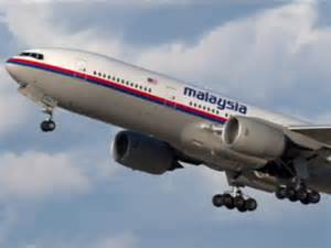
Mystery Still Surrounds the Missing Plane

The circumstances of how Malaysian Airlines Flight 370 disappeared on March 8, 2014 is still being investigated. The nature of how the plane flew off course and is presumed to have crashed in the Indian Ocean is still unknown. The flight left Kuala Lumpur International Airport and was scheduled to land in Beijing Capital International Airport. The Malaysia Airlines plane carried 12 crew members and 227 passengers.
The flight left at 00:44 local time and contact with the plane was lost at 01:22 local time. The Boeing 777’s Aircraft Communications Addressing and Reporting System and transponder was disabled. Air traffic control continued to receive pings for the next few hours. New evidence supports that the plane was diverted west across the Malay Peninsula. The Thai military detected an unknown signal six minutes later of an unidentified aircraft travelling in the opposite direction of the flight path.
Twenty-six countries participated in the search to find the missing aircraft. Early satellite evidence put the plane between a northern area from Kazakh-Turkmen border to northern Thailand to a southern area from Indonesia to the southern Indian Ocean. While radar evidence is helpful, the total search area is a vast 2.24 million square nautical miles, which converts to 2.97 million square miles, comparable to the size of the United States. However, many countries pitched in and contributed search aircraft and ships.
“This is an enormous search area,” Hishammuddin Hussein, the Malaysian defense and transport minister said. “And it is something that Malaysia cannot possibly search on its own. I am therefore very pleased that so many countries have come forward to offer assistance and support to the search and rescue operation.”
On March 24, 2014, satellite data by a British satellite company analyzed that the plane went down over the southern Indian Ocean. This ended the hopes of anyone surviving. The nature of the analysis is unknown, but the plane’s last position was in the middle of the southern Indian Ocean.
Both pilots of the plane have been investigated. Neither seems to be involved, one is a veteran and the other is less experienced.
Reports also say the plane dropped to altitudes of 12,000 feet and sent no emergency signals
Debris was also found off the coast of Australia but it is unknown if it is from the plane or simply from shipping cargo. Hundreds of objects have also been confirmed to be found.
Many questions remain unanswered. Was the plane hijacked? Were the pilots involved? How come nobody saw the plane if it went off course? Is this satellite technology reliable?
The technology to find the plane is described as a satellite that determined the location based on pings. Through the expansion or compression of the signal, the direction of the plane can be determined. Based on this technology, it is also believed it can more specifically determine where the plane is.
“They know by nanoseconds whether that signal was compressed a little — or expanded — by whether the plane was moving closer or away from 64.5 degrees — which is the latitude of the orbiting satellite.” explained CNN Meteorologist Chad Myers
The Malaysian president is confident on these conclusions, announcing that all lives are lost.
“This is obviously a major tragedy,” said Inmarsat Senior Vice President Chris McLaughlin. “The only thing you can hope is that from this, just as the Titanic resulted in (new safety legislation), that from this, there will be a mandate that all aircraft should be constantly tracked.”
Your donation will support the student journalists of Freedom High School - FL. Your contribution will allow us to purchase equipment and cover our annual website hosting costs.

Kevin “K.Chow” Chow is currently a senior at Freedom High School. He was born in Auckland, New Zealand and his family relocated to Australia and Tampa....


